


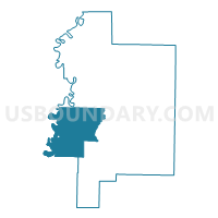
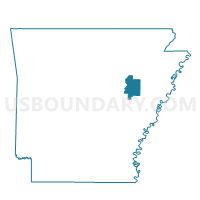
Gregory Precinct 6, Woodruff County, Arkansas
About
Outline

Summary
| Unique Area Identifier | 528553 |
| Name | Gregory Precinct 6 |
| County | Woodruff County |
| State | Arkansas |
| Area (square miles) | 71.31 |
| Land Area (square miles) | 69.81 |
| Water Area (square miles) | 1.50 |
| % of Land Area | 97.89 |
| % of Water Area | 2.11 |
| Latitude of the Internal Point | 35.11653100 |
| Longtitude of the Internal Point | -91.37162590 |
Maps

Graphs
Select a template below for downloading or customizing gragh for Gregory Precinct 6, Woodruff County, Arkansas


Neighbors
Neighoring Voting District (by Name) Neighboring Voting District on the Map
- Calhoun Voting District, Prairie County, AR
- Cotten Plant/Freeman Precinct 7, Woodruff County, AR
- Cypert Voting District, White County, AR
- Des Arc TWP Voting District, Prairie County, AR
- Francure Voting District, White County, AR
- Howell Precinct 12, Woodruff County, AR
- McCrory Rural Precinct 15, Woodruff County, AR
- South Rural Augusta Precinct 5, Woodruff County, AR
Top 10 Neighboring County Subdivision (by Population) Neighboring County Subdivision on the Map
- Augusta township, Woodruff County, AR (2,598)
- De View township, Woodruff County, AR (2,432)
- Cotton Plant township, Woodruff County, AR (717)
- Calhoun township, Prairie County, AR (300)
- Cypert township, White County, AR (283)
- Des Arc township, Prairie County, AR (272)
- Francure township, White County, AR (225)
- Cache township, Woodruff County, AR (127)
- Point township, Woodruff County, AR (73)
- Garden township, Woodruff County, AR (17)
Top 10 Neighboring Unified School District (by Population) Neighboring Unified School District on the Map
- Riverview School District, AR (7,889)
- Bald Knob School District, AR (7,315)
- Des Arc Public Schools, AR (3,596)
- Augusta School District, AR (3,558)
Top 10 Neighboring State Legislative District Lower Chamber (by Population) Neighboring State Legislative District Lower Chamber on the Map
- State House District 49, AR (32,244)
- State House District 14, AR (25,762)
- State House District 57, AR (24,379)
- State House District 51, AR (23,525)
Top 10 Neighboring State Legislative District Upper Chamber (by Population) Neighboring State Legislative District Upper Chamber on the Map
- State Senate District 28, AR (91,744)
- State Senate District 12, AR (83,956)
- State Senate District 17, AR (71,695)
Top 10 Neighboring 111th Congressional District (by Population) Neighboring 111th Congressional District on the Map
Top 10 Neighboring Census Tract (by Population) Neighboring Census Tract on the Map
- Census Tract 711, White County, AR (6,561)
- Census Tract 4901, Woodruff County, AR (4,486)
- Census Tract 706, White County, AR (4,199)
- Census Tract 4601, Prairie County, AR (3,763)
- Census Tract 4902, Woodruff County, AR (2,774)
Top 10 Neighboring 5-Digit ZIP Code Tabulation Area (by Population) Neighboring 5-Digit ZIP Code Tabulation Area on the Map
- 72143, AR (35,169)
- 72010, AR (6,577)
- 72101, AR (3,378)
- 72040, AR (2,867)
- 72006, AR (2,603)
- 72036, AR (817)
- 72059, AR (37)